Waterwatch Data Portal
Site details
Overview
| Site code | WG_HAZ015 |
|---|---|
| Site name | Hazel Creek at King St Bridge Warragul |
| Status | Inactive |
| Water Authority | West Gippsland |
| Basin | Latrobe River |
| Catchment | Latrobe River |
| Sub catchment | Hazel Creek |
| Reach | 26_1 Latrobe River |
| Water type | Other |
| Council | Baw Baw Shire Council |
| History | View all 297 site visits 03-08-2007 - 21-05-2024 |
| Monitoring organisations |
|
Site visits
 Loading chart
| Date | D.O mg/L | EC µS/cm | pH pH Units | rP mg/L P | Air ° C | Water ° C | Turb NTU |
|---|---|---|---|---|---|---|---|
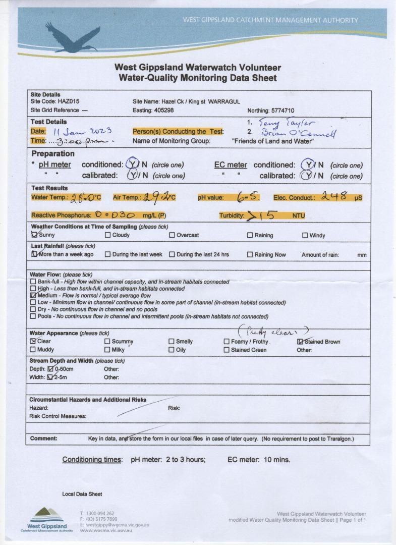
| 11-01-2023 | 248 | 6.5 | 0.03 | 29.2 | 28 | 15 | |
| 02-03-2023 | 267 | 6.6 | 0.015 | 20.3 | 17.9 | 20 | |
| 15-03-2023 | 338 | 6 | 0.015 | 19.5 | 18.6 | 20 | |
| 27-03-2023 | 263 | 5.1 | 0 | 19.5 | 17.8 | 10 | |
| 27-03-2023 | 263 | 5.1 | 0 | 19.5 | 17.8 | 10 | |
| 10-04-2023 | 213 | 8 | 0.015 | 13.7 | 13.3 | 10 | |
| 24-04-2023 | 303 | 6.5 | 0.015 | 16.5 | 14.3 | 15 | |
| 10-05-2023 | 231 | 6.6 | 0.015 | 15.1 | 13.1 | 20 | |
| 25-05-2023 | 235 | 6.5 | 0 | 17.7 | 10.2 | 10 | |
| 08-06-2023 | 188 | 6.5 | 0 | 16.5 | 14.1 | 150 | |
| 22-06-2023 | 221 | 6.6 | 0.015 | 10.8 | 9.4 | 15 | |
| 06-07-2023 | 208 | 6.7 | 0.015 | 18.5 | 9.6 | 15 | |
| 17-07-2023 | 230 | 7.5 | 0.015 | 9.5 | 7.2 | 15 | |
| 01-08-2023 | 210 | 7.4 | 0.015 | 14.5 | 12.3 | 10 | |
| 17-08-2023 | 245 | 6.6 | 0.015 | 10.6 | 7 | 10 | |
| 29-08-2023 | 238 | 7.2 | 0.015 | 15.5 | 11.5 | 15 | |
| 13-09-2023 | 238 | 7 | 0 | 23.5 | 15.9 | 10 | |
| 27-09-2023 | 243 | 6.7 | 0.015 | 15.8 | 14.2 | 10 | |
| 11-10-2023 | 229 | 6.7 | 0.015 | 11.7 | 12.5 | 10 | |
| 26-10-2023 | 231 | 7.2 | 0.03 | 13.7 | 13.7 | 15 | |
| 07-11-2023 | 226 | 6 | 0.045 | 23 | 17.7 | 15 | |
| 22-11-2023 | 278 | 7.2 | 0.03 | 21 | 16.8 | 15 | |
| 07-12-2023 | 342 | 6.8 | 0.015 | 19.9 | 17.2 | 15 | |
| 21-12-2023 | 274 | 7.5 | 0.015 | 26 | 21 | 10 | |
| 17-01-2024 | 224 | 6.1 | 0.03 | 19.9 | 20.9 | 15 | |
| 30-01-2024 | 341 | 6.5 | 0.03 | 21 | 19.5 | 15 | |
| 12-02-2024 | 230 | 7 | 0.03 | 25 | 21 | 15 | |
| 01-03-2024 | 286 | 6.2 | 0.03 | 17 | 18.8 | 30 | |
| 13-03-2024 | 268 | 6.3 | 0.03 | 19.7 | 19.7 | 30 | |
| 28-03-2024 | 258 | 6.7 | 0.015 | 18.2 | 15.8 | 20 | |
| 12-04-2024 | |||||||
| 30-04-2024 | 331 | 0.015 | 12.7 | 10 | 10 | ||
| 08-05-2024 | 284 | 6.7 | 0.03 | 16.5 | 12.5 | 10 | |
| 21-05-2024 | 294 | 6.3 | 0.03 | 11.6 | 11.2 | 10 |
Habitat
| Date | Comment | Bank Erosion Stability | Bank Vegetation | In Stream Cover | Riffles Pools Bends | Verge Vegetation | Overall |
|---|---|---|---|---|---|---|---|
| 12-04-2024 | Good 4 | Fair 6 | Good 8 | VeryPoor 1 | VeryPoor 2 | 21 |


All content, files, data and images provided by the Waterwatch Data Portal and Gallery are subject to a Creative Commons Attribution License
Content is made available to be used in any way, and should always attribute Waterwatch and www.vic.waterwatch.org.au
.png)