Waterwatch Data Portal
CO_MOE070 Moorabool River East branch @ Egerton-Ballark Rd
6 April 2016
Site visit details
Overview
| Catchment | Moorabool River |
|---|---|
| Site | Moorabool River East branch @ Egerton-Ballark Rd CO_MOE070 |
| Date and Time | Wednesday 6th April 2016 14:10pm |
| Approved | Approved |
Notes
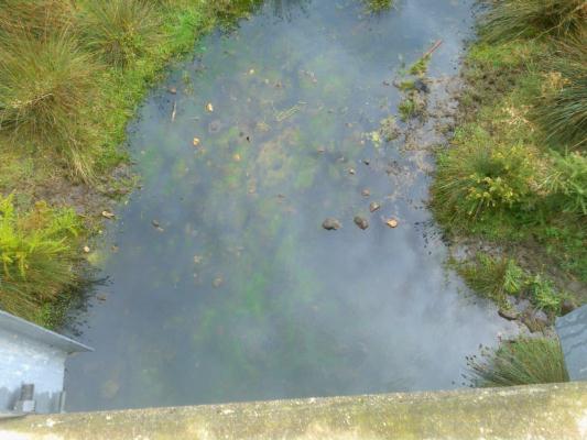
Looking down from the bridge on the downstream side. There is lots of green mossy growth in the stagnant pool of water. The water appears clear but has a darker overall appearance than it normally does. When checking turbidity water looks slightly milky. (I think the lighter areas on the water surface in the photo are reflections of the clouds, the appearance was a more uniform dark look with the naked eye.)
Physical Chemical Tests
| D.O. % | D.O mg/L | EC µS/cm | pH pH Units | rP mg/L P | Air ° C | Water ° C | P mg/L | Turb NTU | |
|---|---|---|---|---|---|---|---|---|---|
| Sample | 42 | 4.1 | 2700 | 6.9 | 0.0231 | 14 | 14 | 14 |
| Weather | cloudy |
|---|---|
| Last rainfall | During the last 24 hours 5 |
| Flow estimate | STAGNANT: No continuous flow in channel but channel continuous (in-stream habitats connected) |
| Water Appearance | Clear,Milky,Other: Clear but dark from bridge.Slightly milky when in turbitity tube.Green mossy growth in pool. |
| Stream depth | 0 - 50cm |
| Stream width | < 2 |
| Hazards | |
| Litter/Pollutants | bottles,cans,packets,paper,plastic,other |
See Diary for photo. The stream width of <2m is taking into account looking up & down stream rather than focusing to much on the large wider pool at the collection point under the bridge.

All content, files, data and images provided by the Waterwatch Data Portal and Gallery are subject to a Creative Commons Attribution License
Content is made available to be used in any way, and should always attribute Waterwatch and www.vic.waterwatch.org.au


